
The West Fork of Fat Man’s Misery Canyon is a remote slot canyon located on BLM land just outside the eastern boundary of Zion National Park – a moderate, yet long and varied adventure, with many rappels, water pools, down climbs and waterfalls. Despite its proximity to one of the most popular parks in the country, you probably won’t see anyone here.

We were well sleep deprived and generally behind schedule as we racked up for Fat Man’s just inside the east entrance of Zion National Park. Our technical equipment (detailed more meticulously below) included two harnesses, a 50 meter rope, rappel gear, an emergency ascender and natural anchor materials including webbing, rappel rings and slings. In truth, we just didn’t know what we were getting into, so we brought a smorgasbord and desert. The guidebook we used, while certainly thorough, is a touch primitive. We knew there was no established trail, there would be at least seven rappels not to exceed eleven meters and there was a high probability of waist deep water, likely hypothermically cold but not sustained, meaning we’d hopefully be able to escape quickly. The topography seemed favorable, relatively non-committing with several bail out points. Zion canyoneers typically wear wet-suits until true summer, since water temperatures are much lower and levels much higher in spring. Being late-April we were toeing the line and hedging bets towards positive. Due to a late arrival the night before and a significant scheduling crunch, we hadn’t time to rent wet-suits. Instead we packed a full change of dry clothes including down jackets, long underwear and gloves to weather the aftermath.
Love Ten Thousand Too Far? Used it to fuel an amazing adventure? Support independent mountain journalism with $5.10 per month through Patreon (and receive extra bonus content), or with a one-time donation. Any and all support is greatly appreciated.
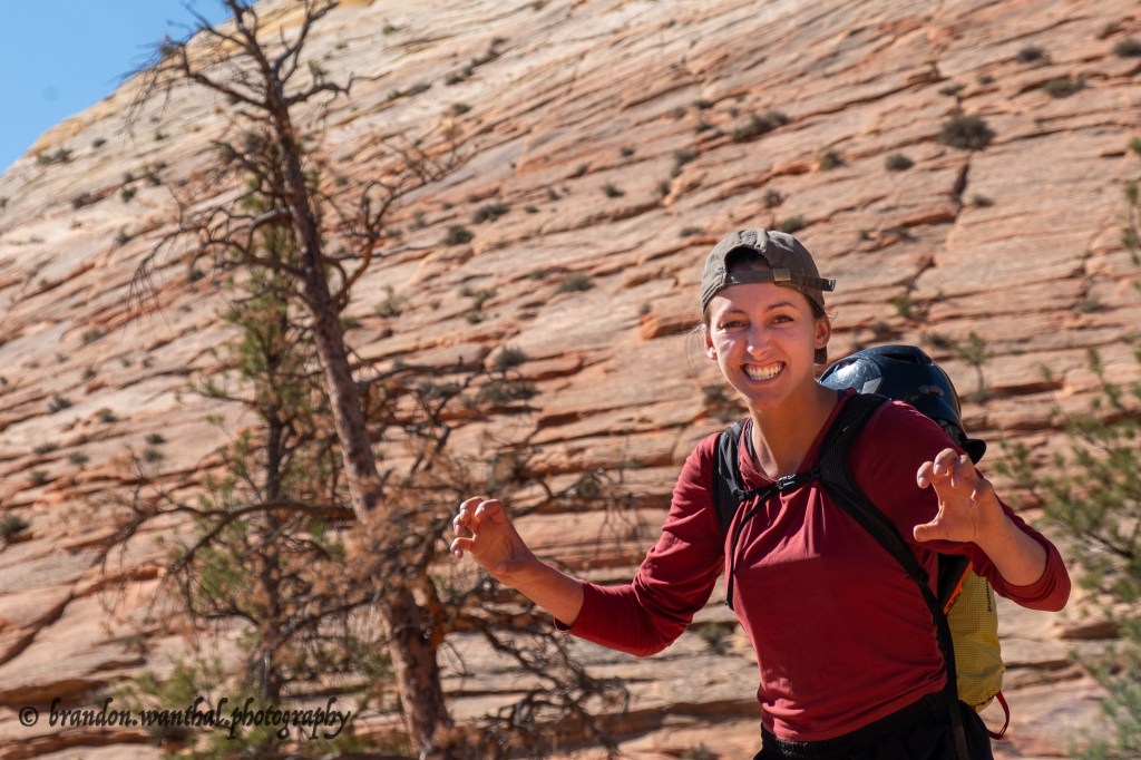
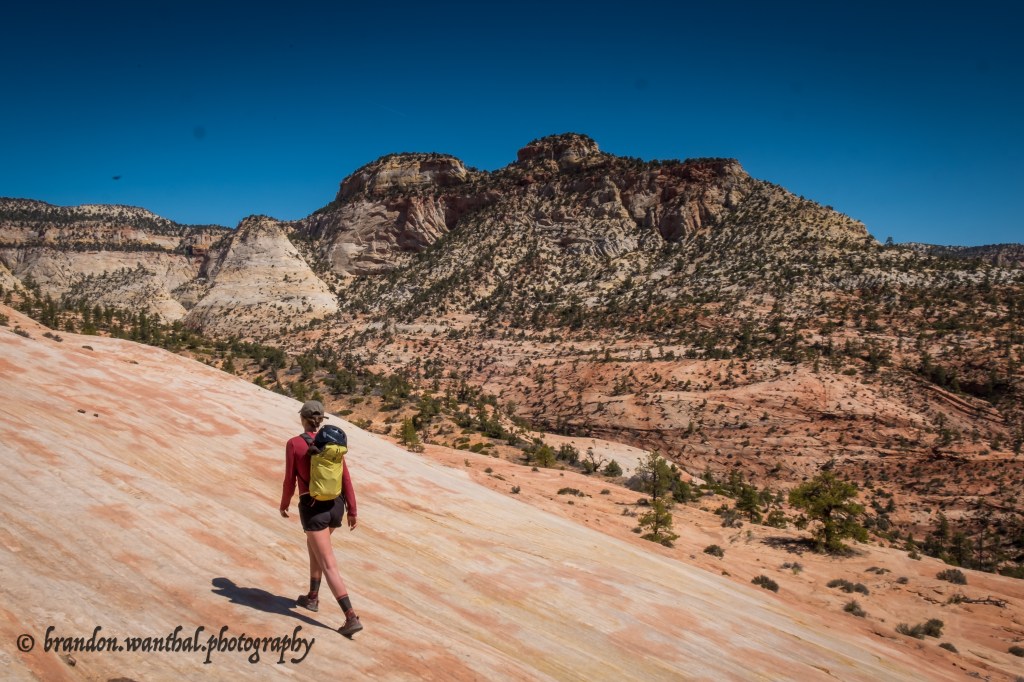
Reaching the entrance to Fat Man’s was the first crux, a long and confusing cross-country connection of indistinct hiker and game trails. We set off from the Checkerboard Mesa viewpoint around 10:45AM heading due south towards a bushy canyon separating the mesa and another massif to the west. While the trail was certainly manageable, it didn’t necessarily qualify as well-maintained. The path was mostly sand, blunting efficient progress by swallowing our tennis shoes in inches of silt. Through cactus beds and over down trees we plunked, topping out on “Checkerboard Pass” and continuing into the vastness of Zion National Park beyond. From the southern foot of the pass we followed a hand-sketched guidebook map and deployed supplemental manual navigation through two washes to the east, eventually spotting the vaguely named “White Slickrock Dome” that marked the western edge of our objective. Delighted but equally concerned over the hours lost to sandy and circuitous trails, we plunged into the canyon with excitement and a gentle sense of urgency.
Fat Man’s is a “Y-shaped canyon” comprised of two forks, east and west. The two forks run interdependently until a confluence about 260 meters before the Virgin River. The east fork is much more benign, having four non-technical slots and one large rappel. The west fork, our adventure ‘du jour’, is more a of a rope assisted circus with five short slots. The “darkest and best” slot lies below the confluence where a 10 meter rappel governs access to a deep, shadowed and twisted adventure through natural waterfalls, pools large enough to swim, sopping wet hand-lines and ultimately a very unique experience. This is the section we feared. But the first five, with short rappels, bone dry pools and ample fixed gear, would be just another walk in the desert… or so we thought.
As we headed down canyon after descending the vague White Slickrock Dome, we questioned whether we were in the right canyon. After all, the vastness and sheer monotony of the naked desert, sandstone washes, mesas and sun baked foliage stretching as far as the eye can see, has the capacity to swindle even the finest navigators. Even though we were dead confident in our route finding, the lack of any tangible landmarks kept our minds off-kilter until the canyon began to constrict and our first rappel came into view. A brand new piece of black webbing was slung around a sturdy, well-wedged boulder with a sparkling new rappel ring ready for action. The sight of fresh gear was a welcomed sign of recent and frequent travel. We slipped into our harnesses anxiously, pulled out the rope and dipped into the goods.

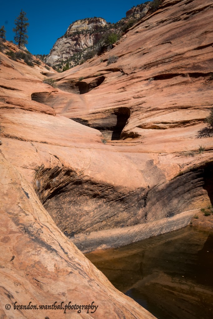
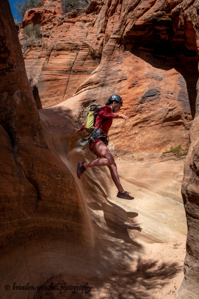
The majority of rock found in and around Zion National Park is Navajo Sandstone, dating back 180-185 million years to the early Jurassic Period. At that time, the entire Colorado plateau and beyond was swallowed by the largest known sand desert in the history of our planet.(1) Over millions of wind and water events, layers of sand were essentially compressed together by force and “glued” in place by groundwater deposited minerals, specifically calcium carbonate.(2) As more sand was deposited and the layers grew thicker, the Navajo Sandstone layer grew an astounding 2,000 feet in depth, mostly underground. The nature of sandstone, much weaker than its cousins granite and limestone, makes it a prime candidate for rapid erosion. As weather patterns changed and hundreds of millions of years of storms battered the area, rushing water turned flatlands to washes, washes to creeks and eventually, creeks to magnificent, hollowed slot canyons with polished walls and marvelous layers of colors, like the finest natural napoleon ice-cream. It’s truly unbelievable how smooth sandstone slots can be. In many sections we chose to butt-slide down small walls instead of jumping, something you certainly wouldn’t do on any normal rock surface. In the first few slots we also encountered many petrified logs jammed between cracks, glossed smooth by the ripping currents of flash floods. Two of these were full on boulder-style down-climbs, but the feel of the silky soft wood turned the thick branches into smooth climbing gym holds. Honestly, meandering tight slots has a very jungle gym feel, where an instinctive set of primal actions takes over as you chimney between tight walls, swing off logs, slide down natural funnels and wade through florescent, mineral dense pools of turquoise and orange. Sometimes the cavernous nature, cooling shade and tropical colored water takes you to another planet… a dream world. Then you round a corner, stepping out into the blood curdling ninety degree sun and remember just what you are, two extremely small specks in a desert that holds just as may secrets as it does cacti.
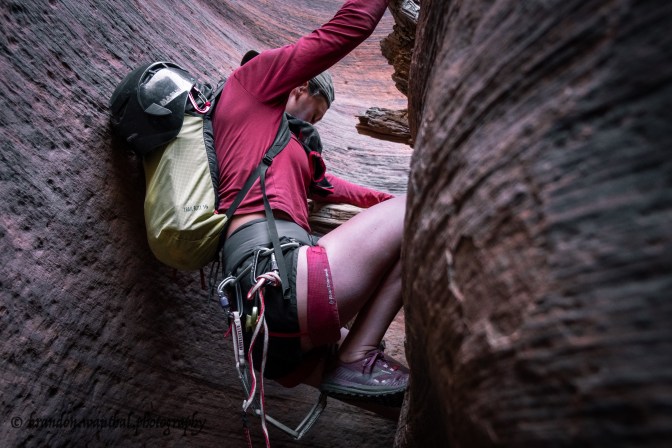


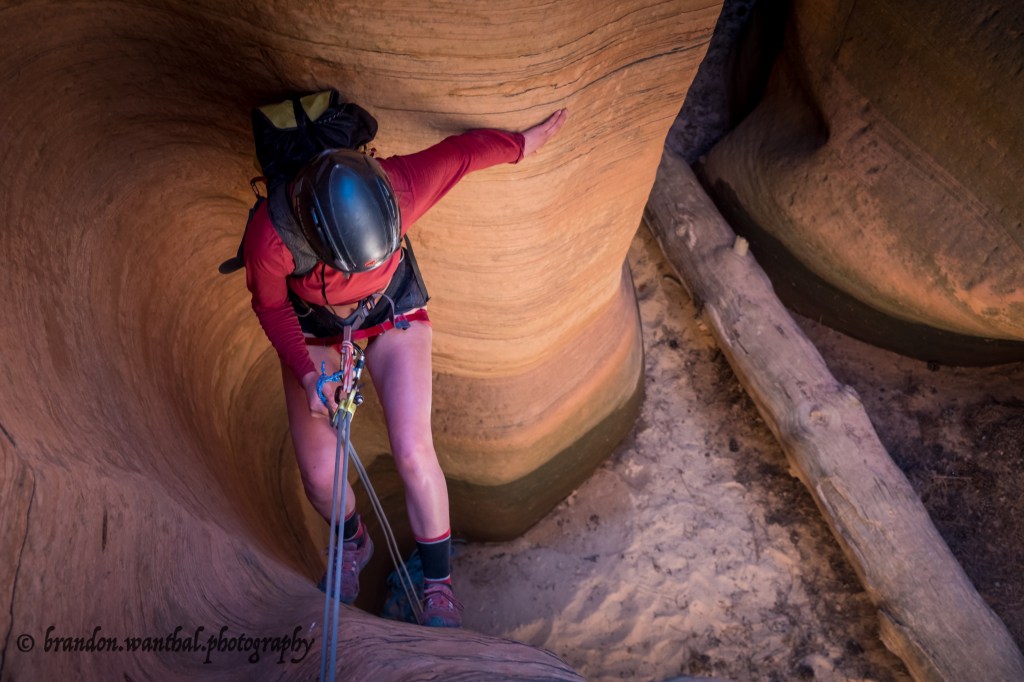
The first five slots went by with relative ease, but not without the expense of valuable time. To recount the rappels with accuracy would be nearly impossible, because it seemed like whenever we put the rope away, we pulled it right back out. We probably did five or six rappels and half as many hand-lines, some off fixed lines and others from ours. We only built one anchor to hand-line assist a tricky down-climb, but in hindsight we both agreed we could’ve done without aid. More important than the number of rappels, hand-lines and jumps was the quality of the fixed gear. Because Fat Man’s gets guided by local companies, all the anchors, slings and bolts were well maintained, flawless and backed up when necessary. We came with pocket knives and plenty of gear to doctor up the place, but had no need for it. Lucky for us, because if we lost any more daylight to this canyon we may have been crawling out by twilight.

Somewhere around the 4-5 hour mark we reached the end of the West Fork, marked by a substantial loss of vertical into a wider canyon below. From our vantage point on the eastern wall we saw several bizarrely shaped pools that looked well over head deep and two oddly placed rappel anchors, one off a large tree on the western wall and another from an exposed notch, both dropping into a shallow slot full of water and down trees. Neither seemed worthwhile by time, scenic or sanity standards. Instead we poked around the eastern wall for an easier way into the confluence below. We found a trail leading to a tree anchor, but opted to down-climb the forty feet of dusty fourth class slabs to save time. The canyon widened substantially as two forks joined forces, the once fifty foot walls increasing in excess of three hundred feet. 150 meters from the confluence we came to the last rappel, about eleven meters from a large boulder through an awkward pinch. We both knew this was the point of no return and the lair of waist deep deep waters. The slot got deeper, tighter and darker the further we dropped. After the rappel we used a jammed log anchor to hand-line a polished slab, and just after pulling the rope hit a deep pool, and another… and another. Later in the day and buried deeper in shade, the frigid bite of the stagnant water no longer felt refreshing. I hypothesized how it would feel to Bobbi and immediately knew we would need to move quickly. Together we plunged into the pools, stopping at each available break to warm up for a few seconds. Eventually the toddler tubs gave way to larger ponds, dark as ink and mysterious as moonless night. Hardly any light seeped from the desperate cracks overhead. The little sun that survived created neon refractions that twirled along the sandstone walls like a psychedelic nightclub. Our splashes and the ambient sound of rushing water was the music, and we danced by swimming and sliding as safely but quickly as humanely possible. In the deepest holes I would descend first, then shuttle both our packs overhead to the next patch of dry land, sometimes around several bends. Then I would return to either photograph or assist Bobbi through. With her thin frame and absence of body fat I was concerned she’d get dangerously cold, but much to my surprise she took the neck deep arctic plunges like a hardened champion. These pools were not sustained and quickly gave way to a short network of shallow cascading waterfalls and a brighter canyon below. We were nearly out, safe but in need of sunlight. A sopping wet piece of webbing with several overhand knots was attached to single bolt to aid the last down-climb before the Virgin River. At this point, the intensity within the canyon was climaxing. The active water rushing underfoot, the tall and sheer canyon walls, our soaked and goose bump riddled bodies and escaping daylight all culminated in an almost tangibly energetic atmosphere. I jumped from the end of the final hand-line into a pool I expected to be equally soul-crushingly cold, but was pleasantly surprised with ecstatic warmth. A spring poured from the canyon rim to the east, and as I reached out to touch the cascade it was indeed in excess of seventy degrees. After flirting with hypothermia in the middle of a barren desert I was somehow now bathing in Fat Man’s exclusive hot tub, joined by fluorescent frogs! Bobbi didn’t believe me as I shuttled our packs to dry land, but when she slipped into the water I could see the same shocked expression on her face. The Virgin River and our escape route was right around the corner – an epic cherry atop a very chilly sundae.


We were out of the Fat Man’s grasp by the eight hour mark but still had several long hours between us and a cozy bed. We battled a severely overgrown shrubby forest, scrambled a matrix of fourth and low fifth class broken blocks and yarded on baby trees whenever necessary to escape a confounding ravine. We switched into dry clothes and ate the last of our snacks as the final glimpses of sunlight escaped the sky. Headlamps illuminated our steps home as we followed faint trails along the western canyon rim. From there we retraced our GPS track, capping our day at the 11 hour mark. Tired and exhausted but chock full of gratitude, we enjoyed a candle lit dinner beneath a clear Zion sky, veggie burgers, black beans and broccoli rabe for all.

Gear Check
Below is a list off all the technical equipment we would bring if we were to do the West Fork of Fat Man’s Misery again:
- 50 meter rope (the guidebook suggested 30 meters, but we opted for the extra security with lots of unknowns and rappels up to 11 meters. 30 meters would likely be sufficient, but more rope might be needed to rappel the slabs before the confluence if the down-climb was in poor shape)
- Standard rappel gear including ATC’s, prusiks and harnesses
- Natural anchor building materials (webbing and rappel rings)
- Dry bags for all belongings
- A wet suit* (excluding dead summer)
*Apparently there are amazing waterfalls 1KM down (west) the Virgin River from the end of Fat Man’s. Because we didn’t have wet-suits and the water level was so high, this was not an option for us.
Sources
- (1) “Navajo Sandstone” National Parks Service, U.S. Department of the Interior, https://www.nps.gov/zion/learn/nature/navajo.htm
- (2) “Sand Dunes to Sandstone.” National Parks Service, U.S. Department of the Interior, http://www.nps.gov/zion/learn/nature/sand-dunes-sandstone.htm.
Guidebook Used: Technical Slot Canyon Guide to the Colorado Plateau, 2nd Edition, Micheal R. Kelsey
Ten Thousand Too Far is supported by Icelantic Skis, Range Meal Bars and Black Diamond Equipment.
Ten Thousand Too Far is also supported by reader donations. If you’ve used this website to plan an epic adventure, consider kicking in a few bucks. The hours spent writing these articles are fueled solely by the desire to enhance our vertical community.
Enter your e-mail to subscribe to updates from Ten Thousand Too Far, only alerts from new posts, nothing else!


DISCLAIMER
Ski mountaineering, rock climbing, ice climbing and all other forms of mountain recreation are inherently dangerous. Should you decide to attempt anything you read about in this article, you are doing so at your own risk! This article is written to the best possible level of accuracy and detail, but I am only human – information could be presented wrong. Furthermore, conditions in the mountains are subject to change at any time. Ten Thousand Too Far and Brandon Wanthal are not liable for any actions or repercussions acted upon or suffered from the result of this article’s reading.

Leave a comment