
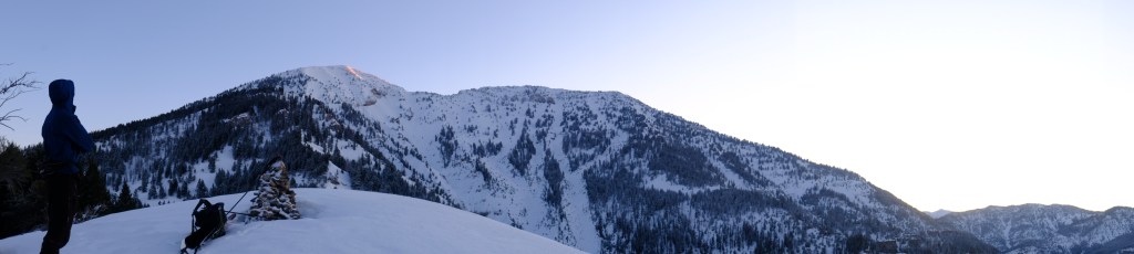
At 4:00AM Easter morning, Carl Osterburg and I met at the pitch black and unsurprisingly empty Pole Canyon trailhead in Victor, Idaho. We both live in town, so the drive was less than five minutes from the confines a warm home. We locked up my car and hopped in Carl’s Subaru to begin the sleep deprived ride over Pine Creek Pass on Idaho’s HWY-31, headed for the Palisades Creek Campground in Irwin, ID. With access to two beautiful mountain locked lakes, Palisades Creek is a popular summer destination, but the area sees little winter traffic. The plan for the day, conceived less than 12 hours earlier from an over-caffeinated Saturday evening map session, was to ski west to east across the entirety of the Palisades Range, following an aesthetic and to my knowledge unnamed alpine ridge I’ve stared at for the better part of five years. The ridge starts on the summit of Baldy Mountain (9835′) and travels due east over the summits of Atkinson Peak (9366′) and Thompson Peak (9481′), before descending considerably and terminating on the modest summit of Fogg Hill (8933′). As seen from Driggs, Baldy appears as a prominent and aesthetic north facing bowl on the southwest corner of the skyline. The ridge we planned to ski connects the next two prominent peaks to the left of Baldy before delving diagonally down towards town. Google Earth predicted our total distance would be 15 miles, but I knew better than to trust that number. Any mapped distance presumes a straight line of travel and doesn’t take into account switch-backs, human error or terrain obstacles. Neither of us knew anyone who’d successfully skied the route (and only a rumor of one failed attempt), but from the look of the map and view from the highway it was too perfect to pass up. I’d never thought of traversing the whole range in a day, but I had thought about skiing all three peaks, and by the time you’re as far east as Thompson, it makes no sense to retrace your steps. On Saturday afternoon the mountains of Southeast Idaho received a modest few inches of light snow on a thoroughly frozen bed of spring crust, just enough to sink an edge but not too much to impede progress or cause an avalanche. The weather forecast called for sunny skies, temperatures in the mid-twenties and low winds; perfect for a traverse. As such, I suddenly found myself crawling up a horrendously steep road cut… through the dirt… with skis on my back… before dawn… by headlamp… on Easter morning. If that last sentence doesn’t say Idaho, I don’t know what does.

Starting any winter mission at 5:18 AM is difficult, but when you’ve never climbed the peak and don’t have a trail to follow it becomes exponentially more complex. The first stage of our day started at the Palisades Creek Campground and followed the southwest ridge of Baldy Mountain directly to the summit. There was no snow in the parking lot and even more surprisingly, none until about 8000 feet. Luckily, we found the unofficial summer “climber’s trail” and were able to follow a faint footpath to the snow-line, where I transitioned to skins and Carl carried on by foot. Together we made our way up a series of alarmingly firm and steep sections of snow, me zig-zagging with ski crampons and Carl boot packing directly. As we reached the first high point on the southwest ridge, glimpses of daylight began to stream over the valley below, illuminating Palisades Reservoir and the vast expanses of Swan Valley below.
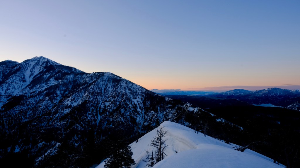


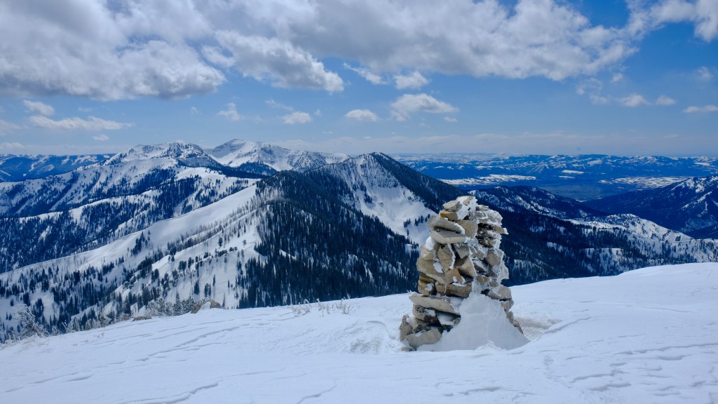
A tranquil morning quickly turned sour as we encountered a few sections of debilitating “punch-crust” that routinely sent us into knee deep snow, making efficient travel nearly impossible. Other sections would be so firm we feared for our ability to self-arrest and wished we had brought ice axes. Even worse, as we neared the summit pockets of newly deposited wind slab were lurking around every corner, forcing us to constantly evaluate avalanche conditions and redirect our ascent route. The slabs wouldn’t have been large enough to bury us, but they most certainly could’ve taken a climber off their feet. The three hour ascent quickly turned to four and change, but nonetheless, we topped out on the summit of Baldy Mountain just before 10:00AM and soaked up some of the most beautiful views Southeast Idaho has to offer.
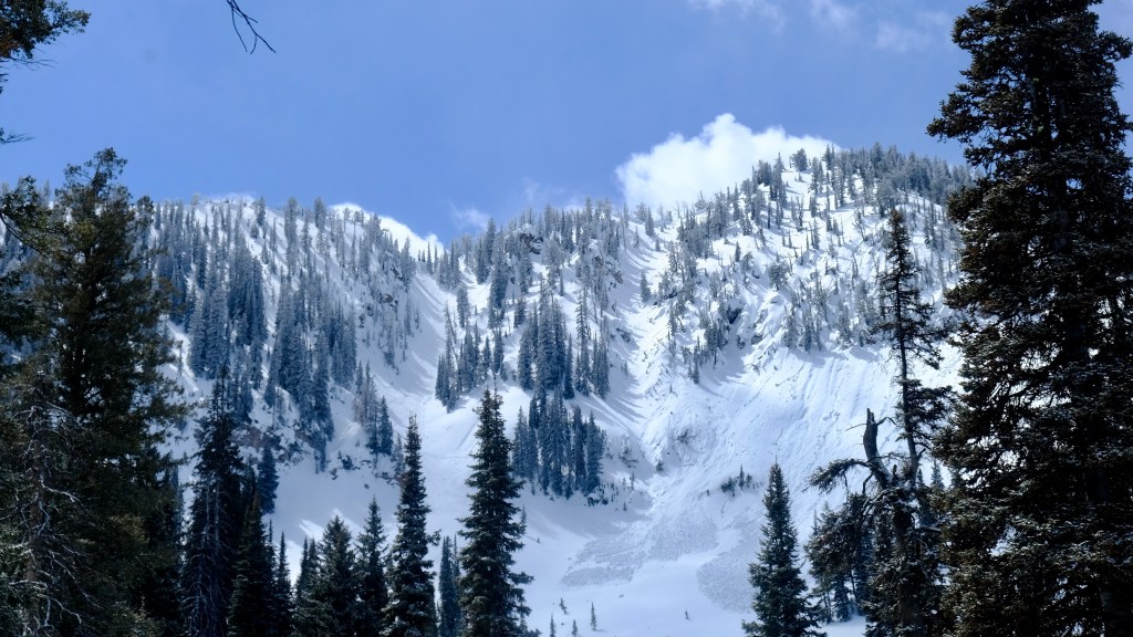
I would love to say we didn’t talk about it, but after such a gnarly and time consuming ascent we pondered for a short moment if we’d lost too much time to continue the traverse. Atkinson and Thompson Peak, the next two mountains on our route, loomed far in the distance; if we thought we’d had it rough so far, two more peaks of similar stature surely wouldn’t help. However, we definitely had the worst climb of the route under our belt and with sunset as late as 7:00PM we still had wiggle room. The northeast bowl of Baldy, our planned descent, is an exposed and complex line on a relatively steep slope that carries extreme consequences should something go wrong. Lucky for us, the wind pockets that lurked on our ascent ridge weren’t present on this aspect, and the snowpack was otherwise very stable. I dropped into the line first, delighted to feel a few inches of powder atop a supportable crust that made for cautious but wonderful turns. Methodically the two of us picked our way down the line, ducking into a chute between two parallel cliff-bands and escaping through a pile of re-frozen avalanche debris onto the apron below. We were proud to look back at our turns on the massive face, turns which looked even more candid the further we skied towards Atkinson.

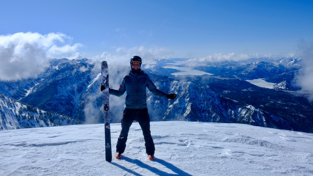
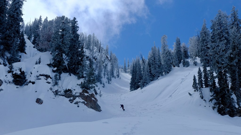
Atkinson Peak is much less aesthetic than Baldy, mostly covered in thick vegetation with a wooded and almost indistinguishable summit. The peak itself is more of high-point along a long rolling ridge of many sub-peaks. The sunny skies held as we made our way towards Atkinson with expansive views of Teton Valley to the north and the Palisades Range to the south. “This is better than anything I’ve seen in the National Park” uttered Carl as we toured in amazement up the mellow ridge to Atkinson. To make up for lost time, we planned to descend the ridgeline proper to the saddle between Atkinson and Thompson Peak, forgoing any skiing that would drop us lower than necessary. However, after a short snack break on the summit, we were pleasantly surprised to find two beautiful, north-facing couloirs cutting gashes through an otherwise completely cliff studded face. Mother nature had us hook, line and sinker; these lines were too beautiful to pass up. After all, we did come here to ski… right? The uppermost couloir was filled with frozen avalanche debris, so we opted for it’s little sister to the east which brought fresh powder turns where it counted and some slightly less desirable, but still very manageable crust on the apron below. I dropped first, and got the benefit of watching Carl exit the gut in conservative style.

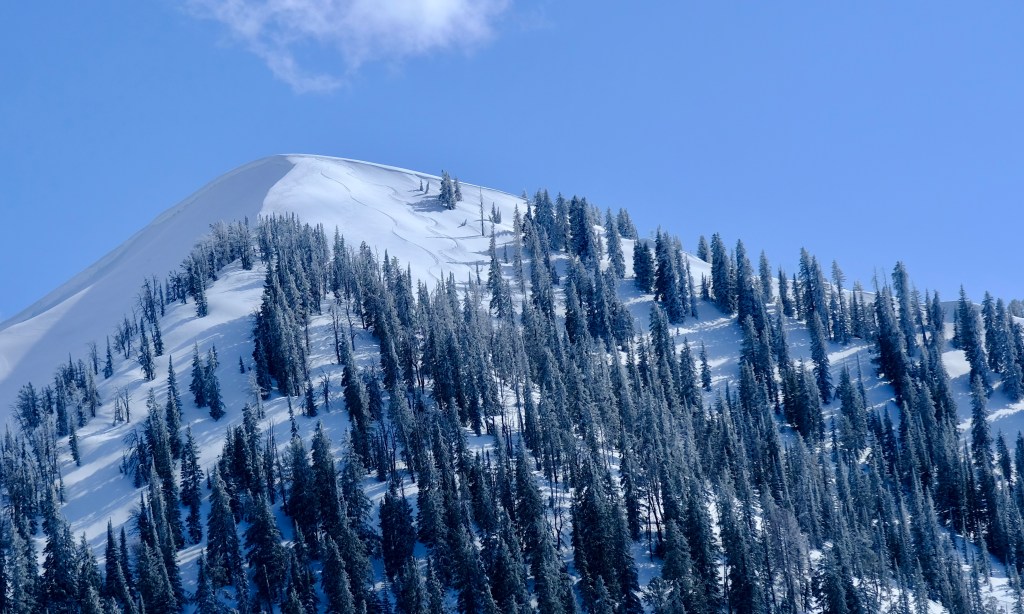
As we sat below Atkinson marveling our line and replenishing lost calories, we checked Carl’s Suunto Watch: Elevation: 7900 feet. We blew it – not completely, but we certainly didn’t make our day any easier. By getting suckered into 2000 feet of powder skiing we were at least 1200 feet lower than where we would have been if we’d stuck to the plan. The climb to Thompson Peak nearly killed me. As Carl forged straight up the south face I dropped down into second gear and began putting slow, methodical switchbacks into the mountain. The sun was radiating off the snow with ferocity, scorching my face, cooking my feet and dehydrating my body. The fatigue of 8000 feet of climbing, coupled with who knows how much further to go, was crippling to think about. Instead, I kept my head low and dissolved into a trance-like state, meandering slowly but steadily until I reached the final ascent ridge. Rejoining with Carl for the final 500 foot push, we debated the same question as we did on Atkinson: stay true to the ridge and save the legs, or ski powder? Powder won again. Shocker. We ripped our skins, took a few pictures and plummeted into a steep field of divine April snow as quickly as we could. The northeast face of Thompson was much less technical than those before, making for epic “party ski” conditions. We hooted and hollered all the way down the well featured face, slashing deep turns as far as we could into the drainage below. The snow was definitely getting deeper the further east we moved, but unfortunately the bulk of our skiing was over for the day. Now it was time for the inevitable slog up and over Fogg Hill (which I aptly renamed Slogg Hill), ultimately to our shuttle car at Pole Canyon.
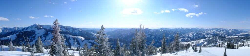
To cut an unnecessarily long story short, we reached the trailhead at 7:20PM after a deceptively long skin up Slogg Hill and two short pitches of low angle tree skiing towards and into Pole Canyon. On the map this section looked far shorter than it actually was. It took us over three and a half hours to reach Pole Canyon from the summit of of Thompson, something we hypothesized earlier would only take two. We cruised the final 2.5 miles out Pole Canyon on a re-frozen snowmobile track, bringing us to the car a few minutes past the 14 hour mark. In total, the traverse covered approximately 17 miles (probably closer to 20 miles, since Carl bootpacked in a straight line), with 11,200 feet of climbing and 10,000 feet of descending. It was Carl’s first time cracking the 10,000 foot climbing milestone on snow, something I’d only done a handful of times. Physically crushed and mentally exhausted we stopped at the Victor Valley Market for sandwiches before tackling the true elephant in the room, retrieving Carl’s car. Driving over Pine Creek Pass as the sun set on the Big Hole Range, we couldn’t help but marvel at how far we’d skied in a single day. What was only a dream less than 24 hours ago had become a reality, and short of the horrific ascent on Baldy, couldn’t have went any smoother. For a range that sees so little winter traffic, the views were some of my most memorable and the ski descents were on par with most anything you’d find in the neighboring and notorious Teton Range. Granted, the approach to the Palisades is certainly longer than Teton Pass, but nothing more than you’d encounter while climbing a peak in Grand Teton National Park. Looking at the full skyline traverse while commuting home from work the following day, I was overwhelmed with a feeling of satisfaction. Not only did we ski three of the most iconic, remote and rare lines of Teton Valley, but we did it in style, safety and under the sunshine of a beautiful bluebird day. It’s days like these that remind me why I love the mountains, and why I will always hold a special place in my heart for the sinfully overlooked wilderness of Idaho.

A Spiritual Take
The Palisades Range would be considered a world class ski destination were it not pitted up against the Tetons. Much like Idaho, which often gets obscured by the shadow of Yellowstone National Park, the Palisades lie mostly dormant while thousands of people flock to Teton Pass, Grand Teton National Park and Jackson Hole Mountain Resort. Even I, who lives directly beneath the Palisades Range and stares at Baldy Mountain every day, falls regularly under the hypnotic spell of the Tetons at the expense of new experiences, like traversing the Palisades!
The analogy I present is a child staring at a shiny object. The child becomes fixated on the object, ignoring everything in it’s peripheral view. As it pertains to skiing, the Tetons are my “shiny object” and the Palisades, along with many other mountains I am fortunate to live around represent the periphery. In life, I think many exhibit a similar behavior, relying on routines, fixating on goals or merely forgetting how incredibly vast the world really is. Where in your life have you been staring at the shiny object, or better yet, what of value might be lying in the periphery?
Want to support? Consider a donation, subscribe, or simply support our sponsors listed below.
A big shout out to Icelantic Skis for supporting me with wooden slidy sticks to romp around the woods with! To check out the Natural 101 and all the other awesome skis they make, head on over to icelanticskis.com
enter your email for updates on new content!


Leave a comment